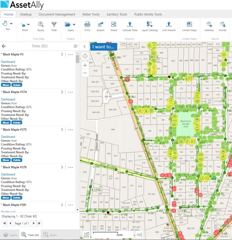
Did you know that AssetAlly allows you with the capability to search for and add various layers of your choosing into your application via the “Layer Catalog” feature? This could be data particular to the county you are in, or from more expansive resources such as NOAA or The Department of Agriculture.
Visualize Your Spatial Data Using the Upload Tool
The Upload Data feature is useful when you have spatial content you'd like to see in AssetAlly. Now, what kind of spatial content could this be? Maybe you have a shapefile from a CAD export or site developer you'd like to visualize. Maybe you have your own surveying equipment and want to take its X/Y coordinates to see if your utility locations are accurate. This data can all be imported and overlayed on top of all your existing GIS data!
How to Add Curb Stops and Water Laterals in AssetAlly
Have you ever wanted to quickly and easily add water laterals into your GIS? AssetAlly gives you the ability to do this on your own. Say, for instance, you had a list of all the lead laterals in your community you would like to enter into your application as a reference for future projects. Learn how in this quick tutorial!
GIS Cheat Sheet for End of Construction Season Planning
Improve Your Budgeting Process by Calculating Sanitary Sewer Lengths
Saving Projects in AssetAlly
Searching for Asset Info Outside Your Map
Are you Using the Buffering Tool to its Full Potential?
Adjusting Map Scale for Printing Exhibits
Identifiable Layers Tool
If you are a frequent user of GIS, you've probably encountered a few situations where you need to see a large number of layers, but only need to access the data for one or two of them. If you've ever wondered how to narrow down what results you'll bring back when using identify tools, then you're in the right place!
Query and Filter Tools
Creating Personal Bookmarks
Water Main Break Tool
Accessing Your Hydrant Data in AssetAlly
Taking Charge of Illicit Discharge
This week we will cover the basics of our Illicit Discharge Inspection Tool! We decided to make the long and grueling inspection process easier for you by putting this tool in your AssetAlly application. Not only does the Discharge Inspection Tool allow you to access important attribute data associated with outfall structures in your community, but it also conveniently produces an organized PDF report containing the information you entered into your GIS.
The Tree Management Tool: A Growing Success
Using the "Linked Maps" Tool to get a Street-Level View of Assets
Changing the Way You Manage Your Storm Water Utilities
The Benefits of Attributing and Linking Asbuilts to Your Utilities
Populating attribute fields in your GIS may seem like a daunting or even unnecessary task at times, but the information being added to your utilities will more than likely come in handy down the line. Aside from being able to access important utility information quickly (pipe size, length, material, inverts, year installed, etc.), it can make searching for particular data in your GIS (such as documents) much easier.
How GIS is Making Donating Easier
Today is World Blood Donor Day 2018. There are various ways in which GIS has contributed to saving lives through blood donation applications. Aside from blood donor applications, there are plenty of GIS based applications that focus on other forms of donation. Now, let's take a look at how GIS is assisting us in making the world a better place!