
Have you ever tried to make an exhibit to print in your GIS? Have you dealt with adding text/markups that don't print quite the size you thought they would? If so, it's likely because of your map's scale. Read on to find out more!
When you're printing a map, you'll often choose a scale to print at - this might be something like 1"=100', or 1"=500'. When using online maps though, you often don't pay attention to scale until you need to print or make a PDF document, leading to text and markup overlapping or displaying in unexpected ways. To prevent this, set your map scale before making markups:
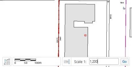
Near the bottom left of your map is a small icon (shown in red above) just to the right of the scale bar. Clicking on this will let you specify what scale you'd like to see your map at.
Now pay attention here, because this isn't quite intuitive. The scale you see here is in inches, not feet. If you want to see the map where 1 inch = 100 feet, then you'll need to multiply the feet by 12 (to get inches) and use that. The image above shows 1 inch = 100 feet = 1,200 inches.
Now when you mark up your map, add text, and make everything perfect, all you have to do is tell the print task to use your current scale and you're all set!
