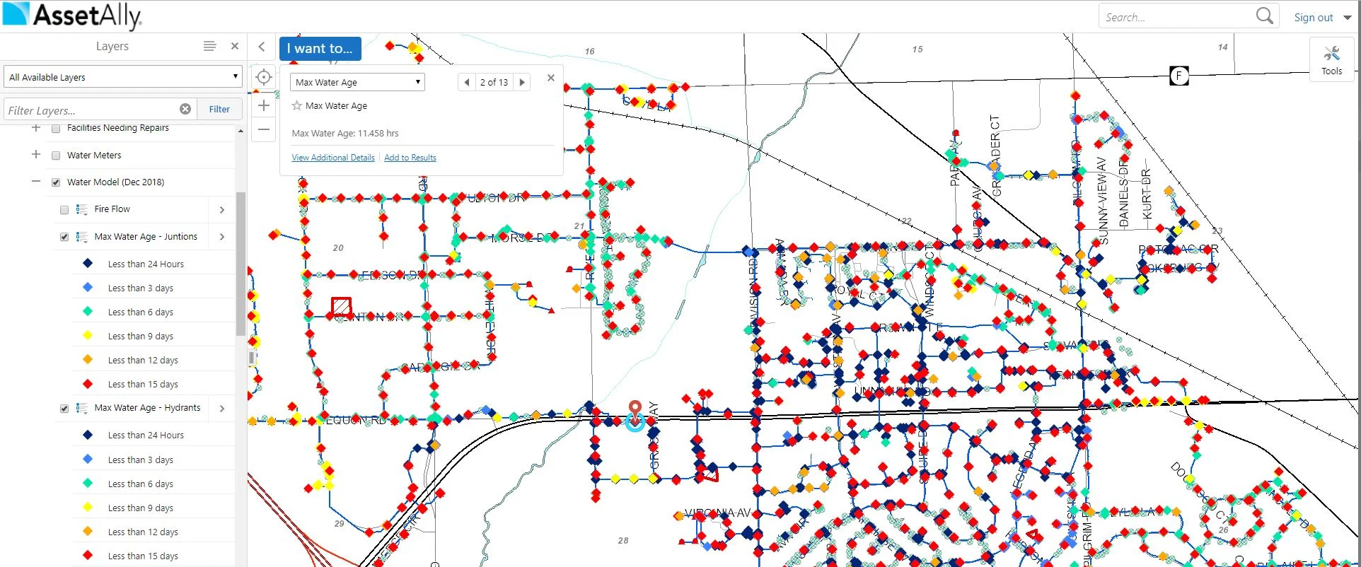
Specialized Tools

Improve Public Outreach with GIS

Improve Public Outreach with GIS

Municipalities are showing more interest in publicly sharing their GIS data, and with good reason! Learn how AssetAlly and ArcGIS Online are helping communities share important public resources and tell compelling project stories using Story Maps, public mapping applications, and Hubs.

End of Construction Season Planning GIS Cheat Sheet

End of Construction Season Planning GIS Cheat Sheet

Why does it always feel like the end of construction season arrives when there’s still too much to do and not enough time to get everything done? While we can’t days to your calendar, our GIS Maintenance Cheat Sheet can help you stay organized and avoid administrative headaches as you navigate this busy time of year.

The Map Gallery and Your Frustration-Free Future

The Map Gallery and Your Frustration-Free Future

Learn how the Map Gallery function in AssetAlly can help you and your team avoid unnecessary interruptions.and increase efficiency by giving you access to your address, utility, zoning, road maps, and more in one convenient, filing cabinet-free, digital location.

Streamline your Processes: The Manhole Inspection Tool

Streamline your Processes: The Manhole Inspection Tool

Manholes are the primary points of access to your community’s underground infrastructure. The AssetAlly Manhole Inspection Tool streamlines the inspection process, giving your team portable, digital access to previous inspection data and the ability to efficiently complete new inspections on-the-go.

GIS Cheat Sheet for End of Construction Season Planning

GIS Cheat Sheet for End of Construction Season Planning

Have you ever noticed that there just never seems to be enough time to get done what needs to be done when it comes to the end of construction season?

AssetAlly has the capability of helping you maintain and organize all of your documents in a safe and convenient location.

Cemetery Tool

Cemetery Tool

The Cemetery Records tool is a specialty tool we offer as part of our GIS services. This tool is tailored to fit your data. Despite the rather grim topic, a Cemetery Records map can be quite efficient when made available to the public. For example, if a community member calls your municipality in search of a genealogy report, you can guide them to the cemetery map; this way, they are able to pull up the information they desire on their own.