Have you ever wondered if you were behind on your sanitary sewer cleaning? In this article we will be explaining how you can obtain information on your sewer cleaning in an organized manner.

Articles
Explore AssetAlly Tips & Tools.
See GIS in Action.
This week is National Infrastructure Week. GIS is a valuable contribution in terms of planning, managing, and maintenance of utility infrastructure. Identifying facilities, tracking work, planning operations and even doing marketing in utilities depends on having all of the data accessible and open for collaboration. Read on to learn more about the importance of GIS in infrastructure management. Success story included!
May 4th is recognized as International Firefighters' Day! So, how hot is GIS when it comes to fighting fires? Firehouse Magazine published an article on how the NAPSG Foundation assists first responders throughout challenging events and disasters by contributing GIS-based field information and situational awareness tools.
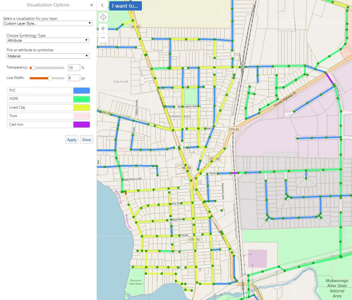
Today we will be showing you another fun way in which we are able to use the "Turn on/off layer visualizations" for symbolizing various attributes on your utilities. In our example today, we will be visualizing the sanitary pipes in our GIS based off of their material makeup. The first step is turning your sanitary pipe layer on. We will then click on the arrow next to the item in the layer list.
As you may know by now, you are able to create and view custom layer visualizations in your GIS. The extent of what you are able to do with these customization options is extensive, so we encourage you to get creative! In this example, we will guide you through the process of visualizing various valve repairs needed by displaying an array of colored markers.
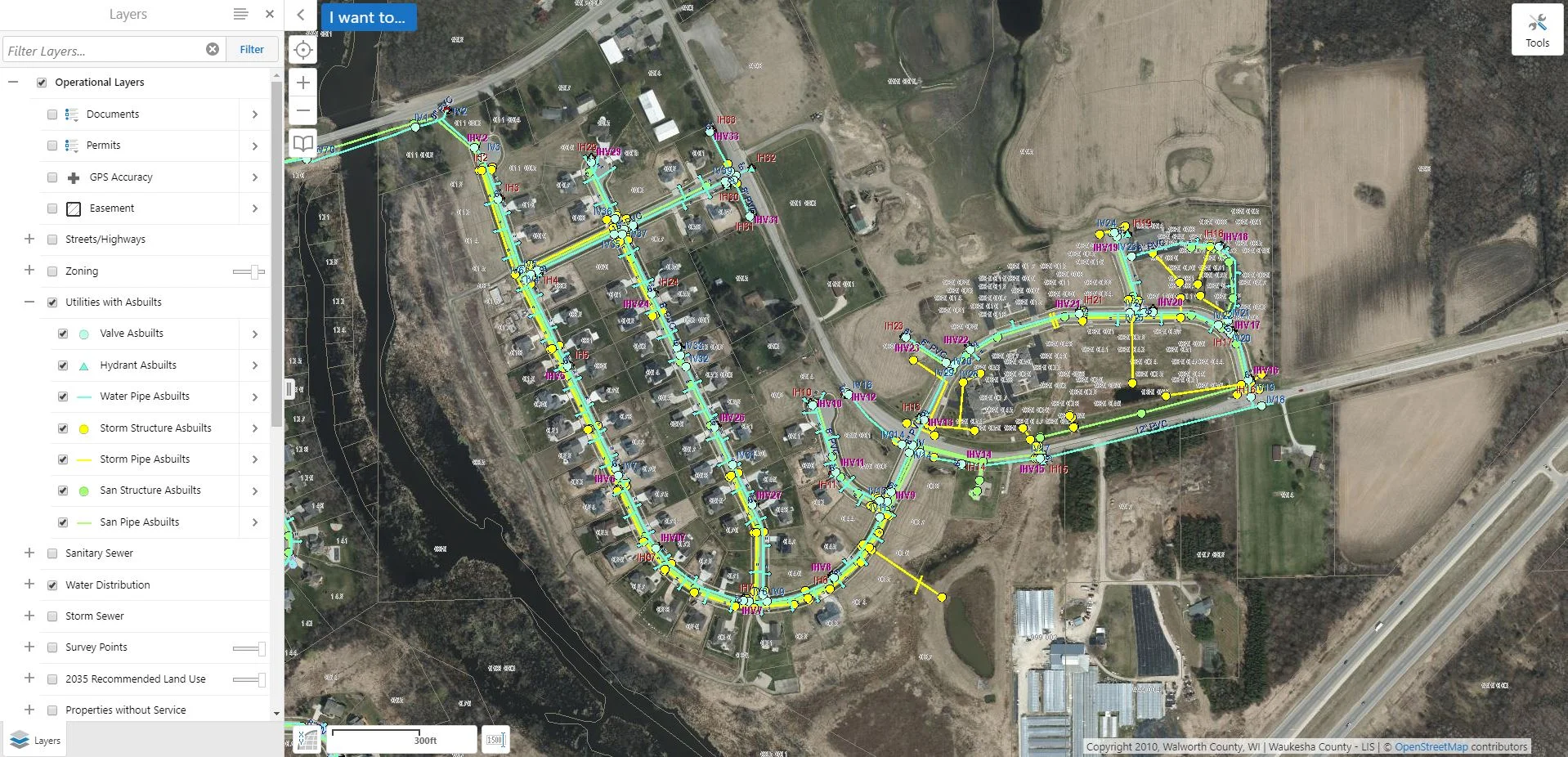
If you are interested in looking at information in an area within your GIS application, then you are probably familiar with the "identify" tool.You may also be familiar with the typically long list of features that show up in the "Identify Results" viewer, even if only selecting a small section on your map. Of course, this list will be smaller depending upon how many layers you have turned on.
The month of March is deemed National Women's History month! We are going to mention a couple (of the many) ways in which women have contributed to the world of mapping. "As the United States entered WWII, trailblazing women like Bea McPherson, BS ’43, took on the task of providing essential handmade maps for the war effort—and charted the course for today’s women mapmakers."
Oh snap! Have you utilized the snapping feature in your GIS before? If not, we are here to give you a quick rundown on it's function/purpose! The textbook GIS definition of "snapping" is: The process of moving a feature to match or coincide exactly with another point or feature's coordinates when your pointer is within a specified distance. It is commonly used to increase accuracy when using a variety of tools including editing, georeferencing, and measuring tools.
Today is recognized as National Boy Scout Day, with the official birthday being February 8th, 1910. That is a long time! Using a paper map and compass are valuable and essential skills taught to Boy Scouts. However, we thought it would be interesting to explore some ways in which GIS has been incorporated into scouting activities. Fun fact: The Boy Scouts (and Girl Scouts!) offer badges that tie into GIS, such as geocaching and surveying.
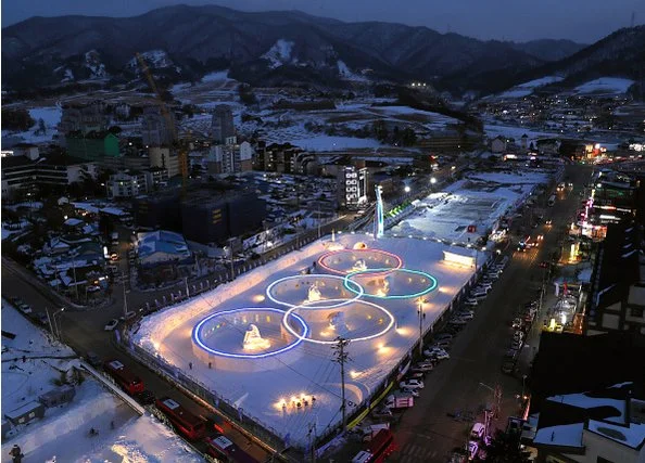
The first Winter Olympics took place in Chamonix, France on this date in 1924! With the 2018 Winter Olympics in PyeongChang (South Korea) approaching, we thought it would be fun to look at some ways in which the events have been mapped. You can click on the image below to learn more about the history of the Winter Olympics!
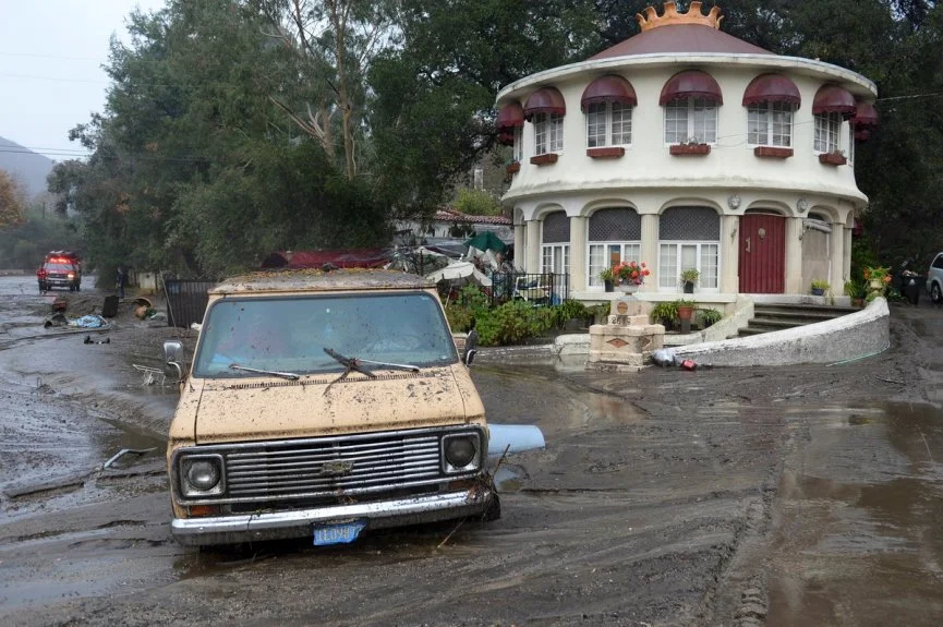
At least 13 lives have been lost in a tragic mudflow that swept across Ventura and Santa Barbara Counties in California earlier this week. Heavy rains have made Southern California susceptible to flooding and debris flows, particularly following the recent wildfires which stripped the steep terrain of vegetation. Vegetation is a crucial component involved in holding the land together during periods of precipitation. The fires transformed the physical properties of the soil, making it less absorbent. Thus, the soil becomes much more vulnerable to erosion.
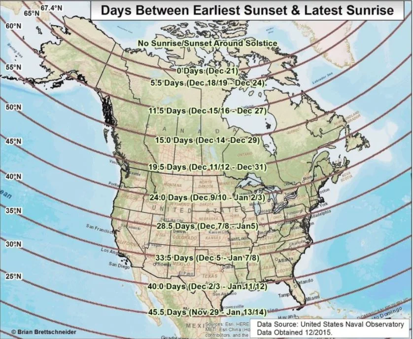
Well, it is officially winter! The time and date of the solstice change ever so slightly by year, but this year’s solstice occurs at 11:28 a.m. Eastern Time. The winter solstice marks the shortest period of daylight in the Northern Hemisphere. However, today is not the day of the latest sunrise or earliest sunset. Rather, most areas within mid-latitudes witness the earliest sunset two weeks prior to the solstice, while the latest sunrise does not occur until the beginning of January!
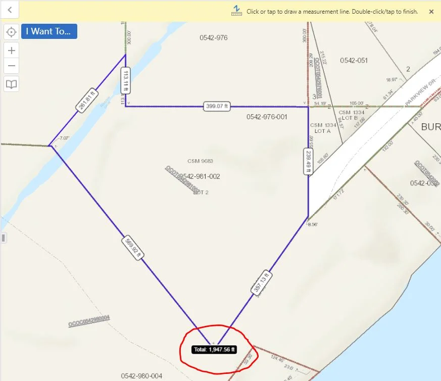
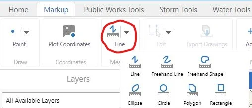
Today we will be going over the measuring tool. First, we want to choose a form of measurement. In this case, we will choose a polygon. The snapping feature allows for more accuracy in measurement. As you may notice in the screen shot below, we are also able to change our units of measurement by simply clicking on the drop down lists next to them.
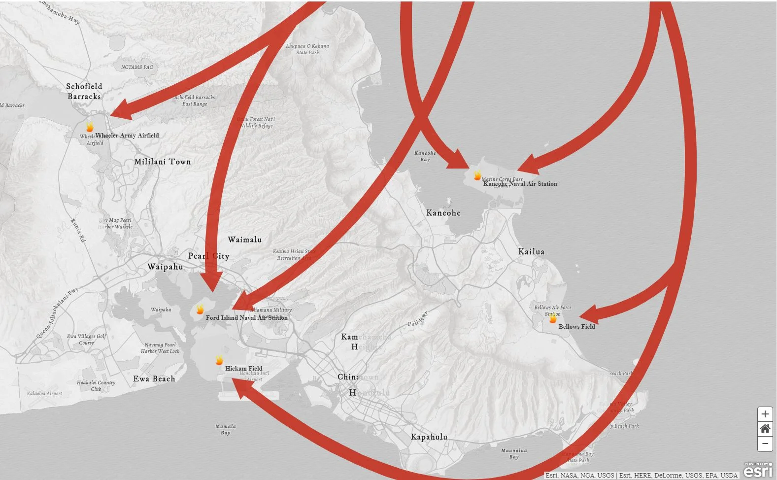
December 7th is recognized as National Pearl Harbor Remembrance Day in the United States, which took place 76 years ago on this date. If you click on the image below you will be linked to an in depth and engaging story map (via Esri). The story map utilizes pictures, videos, and maps in order to retell the complex events that took place at Pearl Harbor.